
Structure plans to provide pathway for growth
What might residential growth look like in the future for Branxholm?
February 7, 2024
Twenty-year plans for new residential and industrial areas across Scottsdale, Derby and Branxholm are being developed to deal with a future lack of appropriately zoned land.
Dorset Council has released documents for public consultation, saying the plans describe how land use, development and infrastructure will be integrated in an orderly manner.
The plans would act as a framework to facilitate future rezonings and amendments – with the council aiming to be proactive, rather than reactive with planning and land use decision making.
“Scottsdale will exhaust all available residential land by 2035 leaving a current supply of approximately 11 years,” the document outlines.
“Subsequently, there is a real need to identify land within Scottsdale that is appropriate and capable of accommodating residential growth.”
The Structure Plan outlines urban areas capable of providing between approximately 30 and 40 years supply of residential land, within proximity to the North East Soldiers Memorial Hospital and the Scottsdale Show and Recreation grounds.
Rural Living zoned land along the north-eastern side of Ringarooma Road to Austins Road and at the southern end of Ada Street, a pocket of Agriculture zoned land at 58-60 George Street between Northbourne Park and Beattie Street, and a larger parcel of Agriculture zoned land on the south-western side of Ringarooma Road between Northeast Park and Careys Road have been identified as being capable of supporting additional residential growth.
The Structure Plan also outlines areas for proposed new Light Industrial zoned land – important given the town has fully utilised available land of that nature.
Land at 54 Ringarooma Road, currently zoned Agriculture but already including uses such as the Council works depot and concrete plant, has been deemed suitable to fill that void with 23 lots possible.
Meanwhile, Derby has been reviewed with plans for future spillover of residential uptake allowed for in Branxholm.
The plan confirms that the bustling MTB tourism and recreation focus of the destination, with visitor accommodation and the redevelopment of existing buildings for food and beverage outlets, resulted in “the displacement of the permanent residential population and a shortage of suitable and appropriately located land for residential growth”.
“Creation of a structure plan for Derby is therefore necessary to ensure there is sufficient and appropriately zoned land to facilitate and encourage sustainable residential growth which is essential to support, complement and balance the trajectory of MTB tourism within Derby,” it says.
“However, through the course of the structure plan process, it has become evident that there are physical limits within Derby to provide land that is capable of supporting growth due to a suite of physical and servicing constraints that affect land suitability.
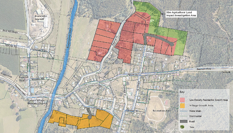
“Branxholm has therefore been included as an ancillary investigation area to identify alternative residential growth areas in proximity to Derby that can be called upon in the event land supply in Derby is fully exhausted.”
Rural zoned land to the west of Renison Road in Derby and Rural Living zoned land along the northern end of Pearce Street in Branxholm have been highlighted as possible growth areas.
The documents are available for public exhibition and comments until March 4, 2024.
Drop-in community information sessions will be held in Scottsdale on Friday, February 16 and in Derby on Friday, February 23.